Our speaker tonight needs no introduction
to anyone working in archeology in the United States or Latin
America, because Professor Deborah Nichols is
both a very distinguished researcher in her own field,
but also an exceedingly conscientious and insightful
member of both the Society of American Archeology, for which
she serves as Treasurer after a series
of other posts over the past couple of decades.
But also on the Archeology Committee
of the American Anthropological Association,
where she has been an elected member of the executive board
and Chair of the Archeology Division, among other roles.
She is or has been on the advisory and editorial boards
of virtually all the most prominent archeology journals
and several in anthropology, published in the US and Mexico.
At Dartmouth, Professor Nichols--
Deb, to our who are legioned, and whom
I consider myself proud to be one, along with Barbara--
serves as the William J. Bryant 1925
Professor of Anthropology and Chair
of Latin America, Latino, and Caribbean Studies.
She's held just about any post a good citizen
at that fine institution could hold.
I see John smiling over there.
She's a popular teacher, a great colleague,
and friend to all, both in and outside of Dartmouth,
and a terrific advocate for archeology,
for anthropology, for international studies.
Professor Nichols obtained her PhD at the Pennsylvania State
University, with the late, great, Harvard-trained William
Sanders, who gave the inaugural Gordon R. Willey lecture.
Sanders deeply appreciated Deb's work
on the central question of his own dissertation, water
management and its role in the evolution
of civilization in the Basin of Mexico, among other topics.
She then directed excavations at the Black Mesa Archaeological
Project in Arizona, from 1980 to '85,
which led to her first two books,
before taking up shop at Dartmouth
in 1985, where they know they are lucky to have
her and her extraordinary ethnographer husband, John
Watanabe, who studied the living Maya here
at Harvard with another late and great scholar, Professor Evan
Vogt.
Their son, Aaron, is also with us,
and there must be something in the water around these parts,
because Aaron got his BA at the college
and is now back for more punishment,
getting a PhD in Government under Professor Steven
Levitsky.
It's great that you're both here.
So it would take the next half hour, which none of us
want to do to, list all of Professor Nichols's NSF and NEH
and other grants, awards, fellowships, symposia,
and invited sessions, articles--
60-some odd of them on academia alone--
books, field projects, including some really important
ongoing work at a site called Altica, online databases,
contributions to institutions, and prizes,
including the Gordon R. Willey prize
of the AAA, editorial boards, classes--
man, I'm getting worn out just reading this list.
I don't know how you do all that.
So instead, I'll just read a few of her more recent book titles
to give you a sense of the depth and breadth of her scholarship
that relates to this evenings Gordon Willey lecture.
Most recently, the book, Rethinking the Aztec Economy,
with Francis Berdan and Michael Smith.
She's coauthored so many articles and books,
and those of you who've done it know that that's a lot more
work than just writing the darn thing yourself.
So that's a real tribute to Deb as well.
The Oxford Handbook of the Aztecs,
the Oxford Handbook of Mesoamerican Archeology,
Multidisciplinary Approaches to Social Violence
in the Prehispanic Southwest, with Patty Crown.
Archeology is Anthropology, how's that for a topic?
It was one of Gordon Willey's favorites, actually.
And The Archeology of City-States, Cross Cultural
Approaches.
So really, it's a wonderful honor
to have our pal and great colleague
and fabulous researcher, Deborah Nichols, with us tonight.
So please join me in welcoming her for this evening's lecture.
[APPLAUSE]
Many thanks to Bill, for a very warm, if not too effusive,
introduction that I probably won't be able to live up to.
And to many of you, who've come today to talk about one
of the places that, for me, it's probably
hard to get me to stop talking about it, Teotihuacan.
And actually, it was the first archaeological site
I ever saw in Mexico.
And I'm going to try to talk a little bit today
to put it and the research there in a broader context for you,
because Bill asked me to speak on the topic of directions
of research at Teotihuacan.
And when he asked me, it was about the same time
I was asked to write what's called a memorial for Rene
Million, a central figure in Teotihuacan
archeology for the National Academy of Sciences,
to honor on his passing, his many contributions.
And it got me thinking about what
we knew, how we came to know Teotihuacan as we do today,
and then the directions for where research is going.
So I'll try to put those things in context for you.
And let me begin here, by making a couple of observations
that, one of which that urbanization, the process
of people moving and creating cities,
is probably one of the most important
social transformations that have taken place in human history.
It's one that we are still in the midst of,
as you can see in this graph.
The 21st century represents the first time in world history
that the majority of the world's populations lived in a city.
And yet, this transformation, and it's clearly
a historical one, began in a limited number of places
in the world, in the Ancient World.
And central Mexico, the area where
Mexico City is today, the large geographic basin that it sits
in, was one of these core areas for the founding
and the development of the earliest cities.
And that's what we're going to be taking a look at today.
But giving you some larger context here,
but many people are perhaps not aware of,
in that Teotihuacan wasn't even the earliest of the cities,
there was one slightly earlier one in this region.
But it really began an urban tradition
that has persisted for 2,000 years,
because this part of the world has
been one of the most urbanized places
in the world for over two millennia.
That itself is a striking fact, particularly when
we think of it in the broader terms
that Harvard's economist Edward Glaser has done.
And who looks at it as cities as one
of the great human inventions.
And he certainly looks at it from the bright side.
So these have some little bit of downsides occasionally to them.
You'll notice a little bit of air pollution
in the slide on Mexico City.
But nonetheless, these were enormous--
for each, in their day-- enormous urban concentrations.
How did people make them work?
How did they come into being?
And what are the implications of this?
Particularly striking in the case of Teotihuacan
is the fact that at the time the city began to form and grow
in size, in the beginning of the Common Era,
it had basically been a pretty marginal place
of small agricultural villages.
And here, I'm looking actually, off
to the one edge of the ancient city, looking down,
and you can see the pyramids out in the distance.
So how did that transformation happen?
How did this countryside become one
of the most urbanized places in the world?
And in thinking about that, one thing to bear in mind
is that Teotihuacan is not a place that was ever
completely lost to history.
Its pyramids were so massive that they have
persisted into the modern era.
And it is with some good fortune that this part of Mexico
has been made relatively more rural, that has given us
access to this city as archaeologists in the way that
is not the case, for example, at the great city of the Aztecs,
which underlies most of Mexico City.
And
I encourage those of you have the opportunity
to hear Eduardo Matos Moctezuma to come back for his--
what I'm sure will be a fabulous talk on the great temple
of the Aztecs.
So at the time that the Aztecs began
to form their empire in the 1400s,
Teotihuacan was still an important place historically,
and important place ritually.
The ruler of the Aztecs, Montezuma,
made pilgrimages there.
They saw this as the place where history had been created,
in which the fifth world in which they lived, where
the gods had sacrificed themselves to make time
to launch the universe.
And here, these are representations
from colonial period maps, where they believed at the great--
what we now call the Pyramid of the Sun,
and the Pyramids of the Moon is where a great Oracle resided.
So this place has played an important role
in also providing the historical validation for later cities
and later states in Mexico.
I've called it a world city, in the sense
that there are a handful of ancient cities
who had unusually outside influence
in their parts of the world.
You can think to Rome, is one, Constantinople is another,
where they were important political capitals,
but whose influence extended well
beyond their political boundaries,
and whose influence also persisted in time,
because Teotihuacan continues to have
an important role in the conceptualization
of the modern nation-state of Mexico,
and its conceptualizations of its history.
But going back, during the Spanish colonial era,
the pyramids of places like Teotihuacan did not--
they were not of great interest to Spanish colonizers.
Well, were a place for which antiquities were dug up
and things of curiosity, but by and large, they
didn't receive much investigation,
because that might have raised some questions, of course,
about the validity of the Spanish conquest.
But as Mexico established itself as a modern nation-state,
Leopoldo Batres--
and Bill Fash has written on this quite eloquently--
turned his attention to these pyramids
as part of the way of validating the modern Mexican state,
creating a kind of, as Bill has used the term,
archeology of state in looking at past states.
And his excavations, whether he correctly
reconstructed the Pyramid of the Sun or not,
it did put Teotihuacan and this great edifice
within the historical consciousness of Mexico.
And this really begins to launch an era of investigations
where archeology becomes and has a role in the politics
of the state, that it doesn't really carry here in the United
States as it does in Mexico.
Another young Mexican, Manuel Gamio,
who had been educated early, in one of the earliest
departments of anthropology at Columbia University,
begins to do excavations following something that we all
take for granted today, and that's excavating according
to layers and stratigraphy, because at this time,
they really only believe that there
had been two great civilizations in ancient Mexico, the Toltec
and the Aztecs.
And actually, many people believed
that since they were aware that Teotihuacan was older
than the Aztecs, it must have been
the capital of the Toltecs.
Through stratigraphic excavation,
this is before anybody had radiocarbon dating,
they looked to try to figure out where
to create a kind of history of the past
without having written text.
And here he did it using layers in the soil.
And also importantly, changes in ceramics.
So another point that I'm going to make today
is that while Harvard and the Peabody Museum
is certainly well known for its importance in Mesoamerican
archeology, today it's most often
associated with the great work that has
been done in the Maya region.
Of course, that's where Gordon Willey carried out
his own career.
But Harvard and Harvard-trained archaeologists
were also, and have been and continue to be,
very important in the work at Teotihuacan.
And I'm going to touch on some of those bases
today, beginning here with Tozzer,
who is, again, one of the leading early archaeologists
here.
He did work outside of Mexico City.
He excavated a mound called Coyotlatelco,
in an area near where Gamio had excavated, and identified
this style of decoration of pottery
that we now know dates to the time
just after the collapse of Teotihuacan.
Another Harvard-trained archaeologist,
George Valliant, excavated villages north
of Mexico City where he defined the period that
preceded Teotihuacan and the establishment of the earliest
villages.
And this is one of his excavations there.
Manuel Gamio goes to Teotihuacan to launch what would really
become a signal project that helped found anthropology
as a discipline in Mexico.
And he began it doing archaic magical excavations, here
at the Pyramid of the Feathered Serpent.
And we'll see some more images of it,
so you come aware of why it gets the name the Feathered Serpent.
But he is actually the one who first identified
these fabulous sculptures.
This is a period that, again, they're further laying out,
they're putting where Teotihuacan fits in time.
Of course, today, we have chronologies
that look like this, but Ignacio Bernal,
one of the great figures of Mexican archeology, who's
written about this history, talks about the period
from 1910 to 1950.
And he calls it the period of when
potsherds, broken pieces of pottery were victorious.
Because this was the period of time
they used changes in style of pottery and stratigraphy
to put Teotihuacan in time.
Now, having begun to get a sense that Teotihuacan
was older, and much older than the Aztec world, but how old,
that it dated after the founding of the earliest farming
villages.
But a lot of Mexican archeology was very focused
on pyramids and monumental architecture.
And Teotihuacan con was not seen as a city in 1940.
If you look at books even into 1950--
if you look at books written about the Ancient World
into the 1970s, there are virtually
no places in the Americas that are presented and included
as those as cities of the Ancient World.
They were seen as ceremonial precincts
because they conceived of the ancient polities
and states of the Americas as theocracies, as led by priests.
And therefore, these priests had these places
where they conducted their rituals
and those formed the political capitols.
But a whole series of events, including the Depression,
World War II, the Spanish Civil War, the aftermath of World War
II, and ultimately, the Cold War,
would come to kind of help to reconfigure
and spur the growth of the social sciences
in the Americas, and lead a whole new generation of people
from very different backgrounds to come
to be interested in the archeology of Teotihuacan.
And I'm going to mention some of those.
So the first of these is Pedro Armillas.
He was Spaniard, he participated and he fought in the Civil War,
fled to Mexico after the Civil War,
but was very influenced by readings on a book,
and several books by V. Gordon Childe, who coined
this term the urban revolution.
The recognition that there was a period of time
in human history where there were no cities.
And cities came into being, and that this
was one of the great transformations.
And that archeology could contribute to understanding
these historical developments.
This is a slide of him.
I've discovered that in the age prior to cell phones,
it is much more difficult to find photographs of many people
than today, where there is all of them on Facebook.
But finding of, actually, photographs
of many of my older senior colleagues
has proved a little more challenging.
This is one with Pedro Armillas from 1967.
It's up in the hills above where Mexico City is located.
But Armillas comes to Teotihuacan
and, having read Childe's book, he
begins to think about these pyramids in a different way.
He undertakes and is involved with excavations
at some of its big residential areas in the city.
And he recognizes, and he is the first archaeologist
to actually recognize Teotihuacan as a city.
He actually takes a lot of Mexican archeology
to task for an overwhelming preoccupation with pyramids,
with aesthetics, and he tries to bring archeology
into a larger social science and comparative perspective.
He is a very charismatic individual.
I had the opportunity early in my life to have met him.
I can understand, when you did--
I was with Bill Sanders--
that you just listened to him talk for two hours.
And he was full of ideas and great thinking.
And what happens on the heels of World War II,
and one of the great social reformations
that came out of World War II in the United States
was the GI Bill.
The GI Bill had a significant democratizing effect
on US higher education, particularly, at least for,
Euro-American men, who were able to attend universities
like Harvard and Columbia, who had come out of working class,
in many cases, immigrant family backgrounds.
And I'm going to introduce some of those cast of characters,
because they come a role in the making of the city.
One of them was René Millon.
His father was born in France.
He was a photographer, and a very early aerial photographer,
here in the United States.
René was interested in history, wasn't sure what he wanted
to do with his life, but was able to go to Colombia
on the GI Bill, was fascinated with China.
And finally, he goes to the University of Michigan
after he gets his undergraduate degree,
takes some anthropology courses, including
some by one of the great figures, Leslie White.
And this draws him, he thinks, anthropology, this
is a really interesting discipline.
They're new, they're not set in their ways,
I can think creatively.
They'll let me do things comparatively.
And he begins to think archeology is a way
to do comparative history.
Well, he can't work in China.
This is the media post-World War II era.
And Gordon Willey offers him data
from the Viru Valley Project for a Master's thesis at Columbia.
And having written his Master's thesis,
Willey suggests to him that he actually go to Mexico
and he meet this young Spanish archaeologist who's
full of ideas, Pedro Armillas.
So it's the 1950s--
early 1950s.
Million had served in the Pacific during World War II.
He doesn't particularly want to get drafted again
for the Korean War.
So he and a bunch of other graduate students from Columbia
get in a car and they drive to Mexico City.
He goes with Pedro Armillas to Teotihuacan.
Armillas shows him around, and to use René's words,
"That was it.
I was hooked.
I knew where I was basically going
to spend the rest of my life."
And that was the case.
At the same time, a son of an Irish
immigrant who grew up on Long Island, who
read a book by another famous Harvard historian, William
Prescott, who wrote books about the conquest of the Aztecs
and the conquest of Peru.
Bill Sanders had read these.
As a kid, he was fascinated.
That actually began his interest and the Aztecs.
So when he came to Harvard, he knew
exactly where he wanted to go and where he wanted to study,
and that was over here to the Tozzer Library.
And at this time, Gordon Willey--
who's in this lecture--
had done work in Peru that proved
to be path-breaking for archeology,
because it established a new method in the field of what we
call settlement pattern survey, of actually looking
at the distribution of archaeological sites
over the landscape.
Willey introduced Sanders to this idea,
who was also getting ideas.
The GI Bill allowed them actually
to take courses in Mexico at the School of Anthropology.
So there, he met Pedro Armillas, there he met René Millon.
There he met another important figure, Eric Wolf.
And he began to see Teotihuacan as a place
where you can take Willey's idea of settlement patterns
and use it to think about creating
a history of the development of these ancient cities
by looking at changes in settlement over time.
And what happens next in this 1950s,
is he writes a paper for a volume
that Gordon Willey put together from a conference on settlement
patterns in the Americas.
And Sanders begins to lay out his idea
of conceiving thinking about approaching cities,
not just looking at their buildings,
but putting them in a much larger regional context.
While he's doing that, Millon is running around Teotihuacan.
And among a couple of things that he did, is he
and another archaeologist teamed up,
and they decided to do a survey in the area just what is now
to the north and west of the Pyramid of the Moon.
And they discover that there's more mounds,
that this place is much bigger than anybody thought.
They also go on and do some work with another archaeologist.
Millon persuades the National Institute of Mexico
to let him go back in and look at a tunnel that had been
dug in the Pyramid of the Sun.
And they do this, and they look at the stratigraphy.
And they realized this Great Pyramid was built very early
in the history of the city.
Now this is a time when most of my students at Dartmouth,
when they come in to take a class, look at these pyramids
and they have visions of slaves.
All right, of people being enslaved
to build these massive, monumental pyramids.
And Millon quite astutely thinks this is built really early
in this city's history.
These people must have built it, in part
because they believed that what they were doing
was building something good.
And he had a very different conceptualization
for what these pyramids might have meant
and the meaning that they had for people.
In 1960, Eric Wolf, who was now a young faculty
member of Columbia University, convened
at the University of Chicago, a conference
on the future of archeology in the Basin
in Mexico, the area around Mexico City.
Teotihuacan was the place they thought
that they should begin their investigation
of this whole series of ancient cities, this ancient urbanism.
There's Eric's book.
And so in that conference, it was decided that René Millon
would try to make the first comprehensive map
of Teotihuacan, that Bill Sanders would try to conduct
the first regional settlement pattern survey
of the Teotihuacan Valley.
As all this was getting underway in 1960, and 1961, and '62,
the Mexican government initiated another major special project
at Teotihuacan, led by two of Mexico's most
prominent archaeologist Ignacio Bernal, seen here,
and Jorge Acosta.
They excavated along the main avenue
of Teotihuacan, reconstructed facades of public buildings.
Acosta the excavated this building, for example.
What's commonly in English referred to as the Butterfly
Palace, which we now know has all kinds
of military emblems and insignias associated with it.
But Acosta was also the first person
to argue the Teotihuacan was not the capital
city of the Toltecs.
That the capital city of the Toltecs,
in fact, was the city of Tula, located well to the north.
Although, conceptually, Teotihuacan
may have been seen as a conceptual early beginning
of civilization.
So you have this massive project going
on that begins to put Teotihuacan in the face,
for those of you who have been there,
that it takes today, as Millon and his crew,
sets out to map this city.
Now René Millon's father was an early aerial photographer.
And from that, Millon used what he learned from his father
to use aerial photography to actually map the city with.
They used aerial photography also
as a base on which to walk the entire area,
try to figure out the boundaries of the city,
and collect examples of artifacts
from the surface everywhere they found concentrations
of artifacts or remains of mounded architecture.
It was an enormous undertaking.
There had never been such a comprehensive map
of an ancient city ever attempted on this scale so far.
And as Millon himself with later go one to say,
had I known how big an undertaking it would,
I never would have done it.
It really preoccupied his life for the next several decades.
He recognized that he was going to need
some help with this project.
And both brought in a generation of younger archaeologists
to work on various stages of the project,
but also another important figure who
had gotten his education at Harvard, George Cowgill.
George Cowgill had followed in good Harvard tradition,
going into Maya archeology, but he
had been a physics major as an undergraduate student,
coming off of an Idaho farm.
And he had this quantitative background,
just as computers were coming to play in a bigger
role in archeology, allowing us to computerize
massive data sets to apply quantitative analyzes.
Millon's survey had collected a million pieces of pottery.
They started in a place called "The Lab,",
which we still refer to the place
where it's stored as The Lab, but now it
is a two-story high building containing
all of these collections.
And Millon knew that he was in over his head in terms
of being able to analyze this massive amount of data.
And so he sought the help of George Cowgill, who
became the other the part of this team that
led to the publication of the map in the early 1970s.
Now this map is important and several important features that
came to light in their course of doing these collections
and making the survey.
One of which was to discover this entire city
was oriented to a single grid plan,
into a single astronomical orientation
that lies 15 degrees, 30 minutes east of astronomical north.
The original old city was--
let's see if I can find a pointer here--
was up in the very northwestern corner.
And we'll figure out how to turn it on.
OK, over in here, and that soon as the city began to grow,
its rulers audaciously laid out this central avenue.
And they began the construction of massive monumental
architecture.
Virtually every river, smaller streams, and buildings
were all eventually built to conform to this grid plan.
And this kind of orthogonal grid plan
is actually relatively rare in ancient cities.
But it's one of the reasons why, when people go to visit,
they see and recognize Teotihuacan is a city,
because don't cities have orthogonal grid plans?
Well, it turns out, actually, 2,000 years ago, no.
In fact, most of them didn't
Boston still doesn't.
And that's right, and some cities
are still trying to use cows paths as its arteries
for transportation.
So he recognizes this, recognizes
that this must have had some significant organizational
implications about the ability of Teotihuacan rulers
to undertake this.
That it must have some ideological,
it must have had some meaning for them,
in terms of how they oriented the city.
And so for Millon, this told him that religion
was playing an important role in early cities.
He also recognized another early feature.
There were all these little squares on this map.
These little squares each represent
an apartment compound, a multifamily one-story dwelling.
They vary in size and degree of elaborateness of architecture,
and yet they follow a similar architectural canon.
And there are 2,000 of these in this city.
So you have a standardized architectural form
that had never existed before in Mesoamerica.
The city is reorganized with this architectural form.
And here is little layout of the city street,
along the Street of the Dead, as we call it today, standing here
at the Pyramid of the Moon.
There's the Sun Pyramid, with, of course,
people standing on it, because it's still an icon of Mexico.
And here's the interior courtyard,
where you have one of these smaller versions of a temple.
So that these apartment compounds he recognized
were the important social group in Teotihuacan.
There were individual families.
The families who lived in an apartment compound
shared similar occupations, they often
shared some more ethnic and class orientations,
they were integrated with one another
through ties of kinship and marriage as well.
And I'll point out another feature which
will come important about Teotihuacan,
is that it has a distinctive style of architecture
that it didn't create, but it used it over and over again,
repetitively.
So this style of architecture became a signature of the city.
And abundant uses of white plaster,
in an area where there is no limestone
to make white plaster.
So that's an interesting thing in itself,
where it got this from.
So Millon creates this comprehensive map.
We understand the apartment compound
is fundamental as an architectural and social unit
in the city.
At the same time, Sanders is doing
the archaeological survey.
Sanders's vision was to survey the Teotihuacan
Valley, systematically, walk over most--
they cheated-- they didn't really cover the whole entire
valley, but they covered 600 square kilometers of it--
to map all traces of archaeological remains
of all time periods that they could find,
up to the period of the Spanish conquest.
He envisioned this to be the first in a series of surveys
that eventually would cover the entire Basin of Mexico.
When they began the surveys, much
like Millon had the daunting task of figuring out
how to map this big city, they had the daunting task
of figuring out how to actually implement pedestrian survey
on a large scale.
Again, today we take for granted that you can just
turn to Google Earth and get an aerial photographic view
of the landscape.
That was not the case in 1960.
There were small-scale aerial photographs
that were available.
And Jeffrey Parsons had been an undergraduate student
of Bill Sanders at Penn State.
Bill sent him on to Michigan to work on his PhD,
but Parsons had worked with a geologist one summer.
And this geologist used aerial photographs
for orienteering and mapping geological features.
And he said, we could use aerial photographs
to do the same thing as mapping archaeological sites.
Willey had used aerial photographs,
but in a slightly different way, when
he had done his work in Peru.
Well, just to give you some sense
of the changes in technology, in order
to get an aerial photograph large enough that you could map
features onto while doing field survey,
they had to figure out a way to enlarge the photographs,
because when you bought them, they were only about this big.
So they bought a photographic enlarger.
And one of the graduate students, they
put a bed on a chair in a room, in the town of Teotihuacan.
And they stood up on the chair.
And then this graduate student, with others holding on to him,
took his camera and made other photographs
that they enlarged of the aerial photographs
to take out into the field, typically
on a piece of board like this.
This all seems almost, by today, 50 years later,
pretty crude technology, but this
was cutting edge at the time.
And as Parsons writes, there were only
about a handful of archaeologists
anywhere in the world who were using aerial photography
in the way they were doing it and the way Millon had done it.
What this mapping-- and they did this in the 1960s.
They would go on to do the rest of the surveys of the Basin
of Mexico over a period of about 15 years,
with Sanders completing the final stage of it
in the mid-1970s.
And what they discovered was one of the most dramatic changes
in regional settlement patterns of any time,
anywhere in Mesoamerica.
If you look at these maps, and the size of the circles roughly
kind of represent the size of different archaeological sites.
So as Teotihuacan is beginning to grow here,
there's another major city in the southwestern corner
of the basin named Cuicuilco.
And there are a lot of smaller capitals
of local regional polities.
You turn the clock, and as Teotihuacan explodes
in the first century of the Common Era,
you notice that there are hardly any sites.
85% of the people in this region of some thousands
of square kilometers are all living
in the city of Teotihuacan.
There's another-- I don't know--
5% or so clustered around here.
And then a small group distributed down here.
Eventually, the city of Cuicuilco
itself will be completely abandoned.
So it had acted like a giant vacuum,
pulling people into the city.
And at a really extraordinary change,
and you couldn't have known this if you hadn't
surveyed the whole region.
Because when I was first exposed to archeology in Mexico,
I worked on the last stages of this survey
as a graduate student-- well, now everybody
can figure out how old I am.
And Bill was still wrestling with the fact
of were we going to find sites of this time period
over in the northern part of the basin?
And we didn't.
But soon after, everybody is pulled
into the city of Teotihuacan, you
begin to see Teotihuacan imitation sites out
in the countryside.
So back to our Teotihuacan map here.
So by the 1970s, we have now gone
through this period of time where
we've gone from Teotihuacan as a ceremonial center
to Teotihuacan as a city.
And conceptualizing future investigations
on the basis of seeing it as a city.
There was one other key player in this.
Or two, really, others.
First the Institute of Anthropology and History
that has an archaeological council in Mexico,
over this period of time, grows.
They become responsible for major archaeological sites
and the care and protection of them.
But they're also going through a professionalization
of the training of archeology, how you do archeology,
and beginning to create their first generation
of doctoral students coming out of the National University
in Mexico.
And one of the earliest students was a woman,
one of my contemporaries, Linda Manzanilla,
who would take courses when Bill Sanders was in Mexico.
So the Harvard connection continued
to yet another generation in another continent,
about the importance of survey, about the importance
of excavating residential architecture.
Another important institutional development
that had nothing to do with Teotihuacan,
but had everything to do with the Cold War,
was the National Science Foundation.
The National Science Foundation was created after World War II
to spur scientific research in the United States
in response to the Cold War with the Soviet Union.
And they created a division-- a relatively small division--
for the Social Sciences.
And within that, created a small anthropology division.
All of the funding for the Teotihuacan mapping project,
the funding for the Basin of Mexico survey project,
and for generations of research since,
the principal source of it for American archaeologists
has come from the National Science Foundation,
in the same way that INAH has been the principal support
of research at Teotihuacan by Mexican archaeologists,
and for Canadian archaeologists, the Canadian Research Council.
These were not institutions that were necessarily
created to do inspiring work in an ancient city
like Teotihuacan, but we have been very much
the beneficiaries of this institutionalized support
for research.
And for their seeing archeology as having a contribution
to scientific understanding in the Americas.
So we have this map.
And from the 1970s onward, once this map is published,
this becomes a key way for archaeologists
to think about their research, to think
about where to investigate, and to begin
to ask the bigger and deeper questions about how
did this city function?
How was it first formed?
And why did it come to an end?
So I'm going to take you through what
I've identified as some of the themes of research
that I see being particularly salient
now, that come out of the late 20th century.
And the late 20th century sees some changes in scholarship
within the field of anthropology.
Explanatory frameworks have come to emphasize
more about ideas about agency and not just
the structure of states leading people to act in certain ways,
but how both bottom up and top down work.
It's also a period in which Mexican archaeologists has
written that we've seen a kind of
theoretical and methodological diversification in archeology.
Manuel Gándara refers to it as the time of thematic
archeology, household archeology,
the archeology of gender, geoarchaeology,
you can go down the list.
Others have used the term, this is
the period of ism's in a lot of social science research.
And you couldn't decide, evolutionism, feminism,
you can go down your isms.
But we've seen this kind of diversification of theories.
And Gandara makes an important point about it,
that with regard to places like Teotihuacan,
archaeologists have engaged in a kind
of theoretical eclecticism.
In part, because they're trying to understand
a very complex phenomena.
And they'll use conceptual frameworks
that help them do that.
They move ideas over time, in the same way
that our toolkit has expanded.
So there's not a simple kind of dominant ideology about how
we explain Teotihuacan as there may have been
earlier in the 20th century, or mid-20th century
or late 20th century.
But there is a way in which this is not just a free-for-all,
because one of the other things that I note
about this period of theoretical diversification
is that the archaeologists who work at Teotihuacan
are also very rooted in those archaeological remains.
That the ideas that come up with that those remains
also drive and guide our ideas.
And this has also been a place that
has continued to be one of methodological innovation.
That just as René Millon conceived of mapping an entire
ancient city, little potsherds on the ground,
to not just pyramids, we think about walking over entire
landscapes to plot the distribution of archaeological
sites and to see how that history was formed.
Now we moved into an era where we're
looking at isotopes, and DNA, and very, very tiny things
to help us answer, still, what are some very big pictures.
So one of the themes that emerges out
of the late 20th century, and here,
I tagged my colleague Emily McClung de Tapia,
is what is the relationship of a big city like this
to its environment?
And she conceives of it in a framework
that we call historical ecology, to recognize
that the landscape that Teotihuacan even grew on
had been shaped by the early farmers who live there,
just as Teotihuacan would shape that landscape.
The late 20th century early 21st century
has also seen a great increase in funding
about environmental research and particularly
in the area of climate science.
So we now have had a number of models done by geophysicists,
in some cases, other kinds of climate scientists, that
note periods of increased temperature, decreased
temperature, greater rainfall, and drought.
And our colleagues in geology like
to look quickly through their textbooks on archeology
and see if they can find a correlation between something
in an ancient civilization and their climatic reconstructions.
I'm being a little simplistic here,
knowing which part of the building that I'm in here.
And in Teotihuacan, what Emily has tried to do
is to do this in a much more subtle and nuanced way.
To take a look at some of those models
and say, well, do I see any evidence of a drought?
Either in the plant remains, in pollen remains--
her specialty are plants.
But she took this further and not just looked at the plant
remains from the city, but has gone out into the countryside
to look at how soil and plants have
changed over the long history of the time of Teotihuacan.
And here, I'm just giving you a few images here,
irrigated maize plant remains, and you can see all the trees.
And this is an area near the permanent springs
at Teotihuacan.
Here, to this very eroded landscape
that we often associate with the effects of Spanish colonialism
and the introduction of sheep and massive sheet and gully
erosion.
So you can't look at the landscape
today and think this is what it looked like to Teotihuacanos.
Moreover, their ecological footprint,
as we use today's parlance, extends well
beyond the Teotihuacan Valley.
There were too many people in that city
to feed it from the lands immediately around the city.
They had to bring in food from other parts
of the Basin of Mexico.
And that probably had something to do
with why they may have established colonies in places.
But it wasn't just food, there were other kinds
of resources they needed.
All that lime plaster, for example,
had to come from an area where there are limestone deposits.
You don't get lime any other way.
And there are none of those around Teotihuacan.
They went areas to the north, particularly
around the Toltec city of Tula.
And if you do the calculations of the amount of wood
they had to have burned to create
that line, probably Teotihuacan's biggest
environmental impact came from lime extraction
up around the Tula area.
And I suspect they left some parts of the Tula area looking
like this after a couple of hundred years
when they'd removed the trees.
So Emily's work has looked at it in terms of historical ecology.
That is an ongoing project.
She now has several generations of students.
And that's another point I want to make
about our understanding of Teotihuacan as a city,
is that the research has been multigenerational by teams
of people collaborating together and bringing
in new generations of students.
I want to turn your attention now to another Harvard trained
archaeologist, Evelyn Rattray.
The Teotihuacan apartment compounds
been a major focus of research.
About the social life of the city,
about the organizations of its economy, how its own ideology
was playing out in households.
One of the observations that René Millon made during
the mapping project is that there were parts of this city
where there were unusually high concentrations of foreign style
pottery.
And we refer to these now as ethnic neighborhoods,
including one, the Oaxaca Barrio,
where people who had originally come from the Southern
Highlands of Mexico.
And she went on to investigate both the Oaxaca Barrio.
She went on to do important investigations in another
that we refer to as the Barrio of the Merchants,
where there were merchants from the Gulf Coast
who seemed to have married elite Teotihuacan women.
The women sort of stayed in charge,
they went off on their merchant expeditions.
But you see great concentrations of foreign pottery in this area
and what they're trading.
Evelyn was also a ceramicist.
She loved all those potsherds in Mexico
and did key work in reconstructing
the chronology of ceramic changes
that help us date things.
And also investigated and took her work outside of Teotihuacan
to other parts of the Basin of Mexico
to try to identify where some of the styles and types of pottery
came from.
And I'm just giving you a few shots here, that maybe--
this is an older photograph from the Oaxaca Barrio of a tomb.
Teotihuacanos and people in central Mexico
do not bury their ancestors in tombs like this.
But people in the Southern highlands of Mexico do.
And here you have people living in Teotihuacan apartment
compounds, but burying their ancestors in Zapotec style
tombs, and practicing Zapotec style burial practices, because
underneath this bowl were remains of the infant's
umbilical cords.
Zapotec people placed their children's umbilical cords
inside of bowls.
So this neighborhood of people from Oaxaca,
we know there were neighborhoods of people from the Gulf Coast,
we know there are neighborhoods of people from Western Mexico,
Guerrero and Michoacán.
We also know, and has only been reaffirmed by very recent work
that some Harvard archaeologists are involved in,
about the presence of people from the southern Maya region.
So this was a multiethnic city.
And it was a city that depended upon immigration
as part of its lifeblood.
Ongoing from the local region and beyond,
Linda Manzanilla has taken up through a series of excavations
of apartment compounds to also ask
questions about how was the city organized internally.
She's particularly pointed to the role of who
she calls intermediate elites.
OK, these are not the rulers who were still
kind of having trouble finding a Teotihuacan, but elites who
organized neighborhoods, who were probably
the administrators of neighborhoods within the city,
through a long series of excavations.
What has particularly struck me about the work she has done
is they probably represent some of the finest household
archeology done anywhere.
She applies everything from ancient DNA
to residue studies on floors to figure out
what people were eating, where they were not only throwing
their trash, but what they were doing in different rooms.
And to actually connect this up to ties and connections they
had to people outside of Teotihuacan.
Again, this theme of immigration and ongoing relationships.
And she argues that these intermediate elites not only
helped administer neighborhoods within the city,
but they actually organized long-distance trade.
Within this context of household archeology,
here is, again, an example from one of the Teotihuacan
apartment compounds.
Those are here to give you some familiarity with them.
But I also want to show how, in the way ethnicity,
how different class differences, these
were also expressed by people who
lived in a standardized residential unit,
and yet also expressed their own individual identities
in interesting ways.
So this is an apartment compound that
was excavated by one of Bill Sanders's students, Rebecca
Storey, for her dissertation work about 30 years ago now.
But you'll notice something about this apartment compound.
This is an area, it's all been plowed,
the big mounts have been leveled by tractor plowing.
But you don't see any white plaster here.
And when they started excavating this compound,
they were really surprised.
And if you look close up here on the bottom,
the walls of this compound, many of them
were made out of adobe bricks.
They have dirt floors.
The people who lived here did not
have the means to have nicely lined plaster floors.
They were, for a period of time, jewelry makers.
They later on became potters.
Probably farmed out in this area.
But if you look here, at this part of the side,
there is a feature that's not typical of Teotihuacan.
And that's a shaft tomb burial.
So they created a nice floored pavement.
They placed one of their founding ancestors there.
And that's something people in west Mexico do.
We now know from isotopic studies
that some of the people in this apartment compound
had their ties to west Mexico.
So this is one end of the social spectrum.
Here's another end of the social spectrum.
This is from a neighborhood that Rubén Cabrera excavated along
the Street of the Dead called La Ventilla.
You can see, again, the lovely plastered floors,
remains of wall buildings, stairs there,
and lo and behold, something else
that he found on the floor, glyphs [? of room. ?]
So there have been some big books
written about how Teotihuacan didn't have a writing system.
And yet, they interacted with people
from Oaxaca who had a writing system.
They interacted with the Maya who had a writing system.
But we had a long book about how Teotihuacan
didn't have a writing system.
And then Rubén finds these glyphs on the floor.
Now we may still debate about the nature of that writing
system, or what language they were writing,
that's our favorite thing to debate with each other.
But they clearly had some system for writing and recording
both history and information in this city.
While there are 2,000 apartment compounds
that have been mapped, this was probably
not the home of everyone.
René Millon noted on the surveys that there were areas where
there were concentrations of artifacts that didn't seem
to have architecture.
For want of a better word, these are called
insubstantial structures.
We still don't know them in great detail.
But I strongly suspect that this is
where probably some of the very poorest people at Teotihuacan
might have resided.
The last big theme that I want to point to here
has to do with pyramids again, at Teotihuacan.
Teotihuacan archeology, beginning in the late 1980s,
re-entered a pyramid age.
But with a big difference than before.
This was not about excavating pyramids
to necessarily celebrate the modern state of Mexico,
it was about excavating pyramids to understand the Teotihuacan
ideology and to understand its system of government.
We don't have large written texts,
as do my colleagues in the Maya region, esteemed rulers
or kings.
What kind of government did they have?
Particularly striking to René Millon and George Cowgill was
this pyramid called the Pyramid of the Feathered Serpent.
That, on its exterior, had these great carvings of the Feathered
Serpent on the outside of this.
And this led them to a hypothesis
that perhaps this pyramid was, in fact, a royal burial tomb.
And that the early Teotihuacan rulers
had been engaged in a cult of rulership,
much like we think of the pharaohs in Egypt.
And that the Teotihuacanos rejected this,
covered over the building.
And maybe this question could be resolved
by excavating a tunnel into it.
And this is George Cowgill standing
on the outside of the tunnel.
As they excavated the tunnel, and Saburo Sugiyama
led these excavations in the tunnel,
they discovered, as they had on the outside, sacrifices
of young adult warriors, richly regaled.
They entered and discovered a chamber--
I was actually working in the lab the day
they broke into the chamber, and they called Mexico City,
and they brought in the engineers.
And there was a scene of great to-do.
This was going to be the burial chamber,
finally answer the question.
And they got in there and they discovered the Teotihuacanos
had looted it.
They'd gone back into the chamber.
So we were left still with a question of had it
been a royal burial chamber?
Or had the ruler been buried outside?
Or maybe this is not where the rulers were buried at all,
because they cover over the pyramid.
And this led people to speculate, OK,
a big change in governance.
But it also launched further excavations of pyramids.
This is a tunnel that was excavated by Saburo and Rubén
Cabrera into the Pyramid of the Moon,
which allowed them to reconstruct the stages
of the history of the development of the Moon
Pyramid.
It was the earliest one.
And you couldn't measure the expansion
of the Teotihuacan state and city
as they enlarged the Moon with each excavation.
Growing up around all this was a young woman,
so Nawa Sugiyama, she accompanied
her father to Teotihuacan, ultimately came here.
Another Harvard graduate who would go on
to do her own dissertation research using
remains from those Moon Pyramid excavations,
where she analyzed the animal bones.
What, to me, has been really striking about these studies
of the monumental architecture at Teotihuacan
is the sophistication by which, even without extensive written
documents, the archaeologists have
been able to get an understanding of the cosmology
and political ideology of this ancient city.
She looks at animal bones.
She actually used MRI, isotopic analyzes,
detailed contextual studies to talk
about how these animals and the images of the animals help
sort of empower the pyramids as great temple mountains that
bring moisture and nutrients to the world.
And a very sophisticated, abstract argument
that comes out of looking these bits and pieces of things we
find in the ground.
To the most recent of the pyramid excavations,
only this one's going below ground.
The archaeologists working around the Feathered Serpent
noticed that on a really rainy day, when the plaza flooded,
there was water that kept going down a hole,
Sergio Gómez investigates that hole.
And discovers that there was this great tunnel excavated
down under, and underneath the Pyramid of the Feathered
Serpent.
I had the opportunity to see the inside of it,
but I'll make two comments.
First of all excavating, this tunnel by the Teotihuacan,
was this with monumental archeology done underground.
And it was monumental archeology by Sergio Gómez and his
colleagues to excavate and study this and the offerings that
have come from it.
Out of it has come now a slight modification
of our interpretations of ideas, because he
argues that this tunnel was a place of rituals.
And what they did was when they finished building the Feathered
Serpent Pyramid, they moved these rituals above ground.
And these were rituals tied into celebrating Teotihuacan
as the place where time began.
And where the government was created.
Here we've had another project done
at the Pyramid of the Moon.
Oops, gone here in the wrong direction.
Here is the tunnel underneath the Sun Pyramid.
The Sun Pyramid work has been done by Alejandro Sarabia,
also further working on this ideology and the meanings
of these pyramids.
Two of the most recent projects involving two
archaeologists here at Harvard, Nawa Sugiyama,
who got her degrees from here, and is now holding
her own tenure line position.
And Bill Fash, in the Las Columnas Project, and David
Carballo, who's also sitting here.
Again, on these issues and questions
about Teotihuacan governance.
And the details of their story are yet
to be told, as they're continuing into the field.
But I think this slide also captures
the image of the archeology as a collaborative endeavor
at this great ancient city.
And now I just want to kind of conclude
the latter part of my talk about talking about that
to understand Teotihuacan as a city,
you can't just look at the city.
You have to go out into the countryside.
And out in this countryside-- and this was a map that Bill
Sanders originally created--
they had to provision the city.
They had to bring resources in from the outside areas
of the city.
And that probably is what encouraged the colonization
of selected parts of the Basin of Mexico,
because when Teotihuacan pulled everybody into that city,
there wasn't anybody out there to bring resources
into this city.
There wasn't an infrastructure to do it with.
They had to create it.
And Justin Jennings is an archaeologist
in Canada, who's written, I think, an important book,
because he makes the argument that maybe these early cities
made states, instead of early states making cities.
That in trying to create an infrastructure in order
to provision themselves, they had to come up
with administrations.
They had to form colonies and create this larger
entity that we call the state.
And at its height, Teotihuacan probably
governed an area of central Mexico
that had between 300,000 and 500,000 people living in it.
Extended to the south into the cotton
growing areas, extended over to the west,
and to the east, where David Carballo has worked,
along major trade routes to at least control or assert
its authority.
And this is a reconstruction of what
the settlement looks like at the time
that Teotihuacan is at its height.
And we'll notice something else.
Is that out in the countryside, our sites
that are now being built with Teotihuacan-type architecture.
This is the remains of a Teotihuacan mound
that's underneath a chapel north of the city.
You can see the plaster floor.
This was done as part of a salvage project.
This is another salvage project located to the northwest
of Mexico City.
The outlines of Teotihuacan rooms and plaster floors.
And that brings me to another point.
And that is 85% or 90% of the thousands of sites
that were found on the archaeological surveys
had been covered over by the growth of Mexico
City and surrounding cities.
So the maps and things that were done
in the 1960s and 1970s, and collections made in combination
with salvage archeology is really
how we're going to understand the larger regional context
of Teotihuacan.
But this is another Teotihuacan period site
along its trade route.
And finally, to the work of David Carballo,
that has finally helped to resolve a big debate
about how important was the role of making Aztec tools
to the economy of Teotihuacan?
We knew there were concentrations of obsidian,
but there were great debates about whether Teotihuacan
attempted to monopolize the obsidian
industry all over Mesoamerica, or maybe it
was just the trash of a few flintknappers.
And finally, after 30 years of arguing about it,
David Carballo and Ken Hirth decided
to actually excavate one of these and resolve it.
We certainly have-- these are concentrations of workshops.
But we now know from technological studies,
it doesn't take very many people to mass produce
lots of obsidian tools.
And this is part of David's larger investigations
of the Tlajinga neighborhood.
This is the obsidian source that lies near Teotihuacan.
We now recognize that markets and commerce
were part of Teotihuacan's economy,
at least within the city.
And these are bowls that they imported, that Evelyn
Rattray originally identified.
This thin orange pottery is made in southern Pueblo.
And the bowls were meant to be stacked,
to be carried by traders from southern Pueblo
into Teotihuacan and other sites.
And this is an image from an outlying site that
was dug in the 1950s, that has brought us, also,
a new understanding of Teotihuacan's larger
regional relationships, as maybe not as centralized as we once
thought they were.
The site of Cerro Portezuleo was dug in the 1950s.
It has a small Teotihuacan platform on it,
Teotihuacan style ceramics, This little water jar.
They're imitations.
They're copies of what was made from Teotihuacan.
But what we discovered when we reanalyzed the material
from this excavation is that the people there
were copying Teotihuacan, but they were actually
importing half as many ceramics from the western side
of the Basin of Mexico as they were from Teotihuacan.
That Teotihuacan did not really dominate the regional economy
and they were bringing things in from outside.
So we have a more complex, I think,
picture that's being painted of its regional relationships.
And now, I'll say just a little bit
about the founding to bring me to one of our last
and more recent PhDs out of Harvard archeology.
Thanks to an undergraduate student
at Dartmouth, who got interested in doing material science
studies, she analyzed some of the early village pottery
that Bill Sanders had collected in 1961
from a site called Altica.
We recognized, and she identified,
that some of this pottery was imported,
but from only knows where, and we didn't even
know whether this site existed.
We went back into the field, found it,
with my colleague, Wes Stoner, and this is Bridget.
She was an undergraduate student at Dartmouth,
so she's dressed in green here, for her thesis presentation.
Of course, she would now be dressed in crimson.
But at the time, some of her blood, at least,
still runs green.
And it was her honors thesis research
that launched our project, that dated for the first time
the earliest farming villages at 1250 BC.
Maize farmers move into this area.
They are part of a larger exchange networks.
So the trading systems that Teotihuacan
took to a whole new scale were established from the beginnings
of these earliest villages.
We came to understand that even this early village was not
socially homogeneous.
We found one individual who had been buried with a jade bead.
And I've worked with a lot of sites out in the hinterlands,
and at Teotihuacan, and I never found a jade bead
in a village or site.
But here, these earliest villagers
had access to them, as well as to a little possum pot.
And to the final piece of our story about Teotihuacan
and its beginnings and its origins,
when I was a graduate student, the story
line when that Teotihuacan grew so big
because the city of Cuicuilco was destroyed
by a volcanic eruption.
Well, volcanic eruptions did have an impact on the city.
But we now know that volcanic eruptions probably
lead people to flee to Teotihuacan,
it didn't necessarily destroy its, perhaps, biggest rival.
But when Popo shot off its head, the impact it might have had
was actually to cut off the trade routes of Teotihuacan
biggest rival city, Cuicuilco.
And René Millon and had made a very astute observation from
the mapping project at Teotihuacan.
In that when they laid out the Street of the Dead
and they reoriented the city, the only low pass
out of the Basin of Mexico is through the Teotihuacan Valley,
where you don't have to go over steep mountains.
And he said they essentially laid out the city so
that it was right at this pass.
You didn't have to control the state merchants.
Anything moving in and out of that part of the region
would go through Teotihuacan.
And moreover, if Cuicuilco's trade routes were blocked
by the lava flows and the ash flows from Popocatépetl,
that would have given Teotihuacan even more
of a strategic advantage.
And so I'll conclude with my final slide.
Is one that I take, that Teotihuacan,
even after its collapse and destruction at AD 550,
continued to be part of the historical memory
of later states and cities.
It has continued to be part of this historical consciousness
of Mexico, part of their own ideology
of the modern nation-state, and their very deep and rich
history.
And that history extends as far north to a little town
of Hanover, New Hampshire, in which José Clemente Orozco was
invited to be the visiting artist at Dartmouth,
early in the 20th century.
And if you've never had the opportunity
to see the only national landmark in the state of New
Hampshire, it is the Orozco murals
in the library at Dartmouth, where
he has a room bigger than this one, which
are covered with his view of modern and ancient history.
And this is where he paints the Pyramids of the Sun and Moon
and the rising of the great figure of Quetzacoatl.
And David told me today there's at least one interpretation
now, around that maybe this was known
as the City of the Feathered Serpent.
Orozco didn't know that when he painted it,
but perhaps he captured something more
about the city's identity.
He thought it was a Toltec city, but now we
know it takes much earlier than that.
So thank you very much.
[APPLAUSE]
 For more infomation >> Brzuch boli? Co możesz jeść, by złagodzić objawy - Duration: 12:32.
  For more infomation >> Top Latino Songs 2018 ★ Latin Music 2018: Pop & Reggaeton Latino Music 2018 - Duration: 1:55:55.
 For more infomation >> TOAD IN THE HOLE | COOKED IN A CAST IRON SKILLET - Duration: 11:38.
  For more infomation >> 特朗普:恭喜敦馬,讚歎人民 - Duration: 5:01.
  For more infomation >> Przemęczenie – 8 produktów, aby je zwalczyć - Duration: 12:22.
  For more infomation >> Audi A4 Allroad 3.0 TDI 245pk quattro Pro Line Interieurvoorv| Panodak - Duration: 1:13.
  For more infomation >> Kaszel Cię męczy? Wypróbuj 5 sposobów z wykorzystaniem cebuli - Duration: 12:12.

 For more infomation >> 설리 3초 삭제 사진 진실과 논란 사진 모음 - Duration: 7:15.
  For more infomation >> Pierwsza pomoc przy oparzeniach wodą - Duration: 12:48.
  For more infomation >> Ordrestyring.dk: Hvordan bruger en bogholder Ordrestyring | Revisor Bogholder Håndværker | - Duration: 2:39.
  For more infomation >> Vietnam travel_ĐI CHÙA LÔI ÂM Ở QUẢNG NINH BẠN NÊN BIẾT_Du lịch - Duration: 14:36.
 For more infomation >> 山健組で継承式、組長交代か | MBS 関西のニュース - Duration: 0:33.
 For more infomation >> 「ミニ」大幅刷新…スマホでドア施錠可能に : 経済 : 読売新聞(YOMIURI ONLINE) - Duration: 1:22.
  For more infomation >> ピューロランド×ネルケ「MEMORY BOYS」上演決定!語り手はマイメロディ - ステージナタリー - Duration: 1:46.
  For more infomation >> Kira and Jack Look Back
 For more infomation >> Sapno ki Udaan | Penned & Recited - Prince - Duration: 2:08.
  For more infomation >> ЛУЧШИЕ ПЕСНИ 90-х ✮ Анжелика ВАРУМ ✮ ТОП 20 СУПЕР ХИТОВ ✮ - Duration: 1:23:50.
  For more infomation >> Žalgiriečių kelionė į Belgradą – skrydžio patogumai, žurnalistų dėmesys ir sutiktas J.Zidekas - Duration: 3:39.

 For more infomation >> EXPERIENCE SOCIALE SUR MSP RATER :/ - Duration: 8:53.
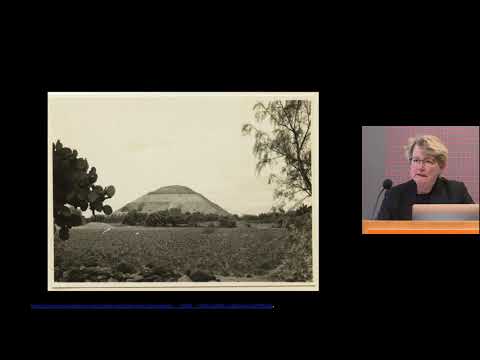
 For more infomation >> SkowZa DZL 2حشومة عليكم ادراري - Duration: 6:00.
  For more infomation >> 殲10撞衫獅式戰鬥機 兩者外表極為相似 而且與以色列有過蜜月期 - Duration: 6:09.
  For more infomation >> 大谷翔平、17日対戦のバーランダーは「凄い球」 勝ち越しへ激突「楽しみ」 - Duration: 4:45.
 For more infomation >> [MAMAMOO中字] 輝人(Whee In) - EASY (Feat. Sik-K) 繁中歌詞 - Duration: 3:17.
  For more infomation >> KOTONOHOUSE & Yunomi (feat. くいしんぼあかちゃん & Azuki) - 恋の星占い、海をさして - Duration: 4:21.
  For more infomation >> TESLA'NIN GİZLİ ŞEHRİ VE UFO BULUŞU - Duration: 3:21.
  For more infomation >> Weekend performing in Gangwon province & The Rose concert🌹// vlog #1 - Duration: 15:07.
 For more infomation >> Škoda Citigo €470,- voordeel 1.0 60pk Greentech Ambition (vsb 18887) voorraaddeal Rijklaar! - Duration: 0:53.
  For more infomation >> MTC Video: Oscar – Connecting Aging Mashines | Microsoft - Duration: 1:58.
No comments:
Post a Comment